

Granholm, DOE Propose Massive Midwest Land Grab
Granholm, DOE Propose Massive Midwest Land Grab

If you live in Illinois, Missouri, Kansas, Oklahoma, New Mexico, Nebraska, South Dakota, North Dakota, or Arkansas, you might want to get your pens and notepads out and get ready to take notes, because the Biden administration is coming for your lands.
On May 8, Jennifer Granholm’s Energy Department (DOE) released a preliminary list of potential National Interest Electric Transmission Corridors (“NIETCs”). Granholm characterized the list as representing another step forward in DOE’s efforts to effectuate statutory powers designed to accelerate the development of electric transmission infrastructure across the country.
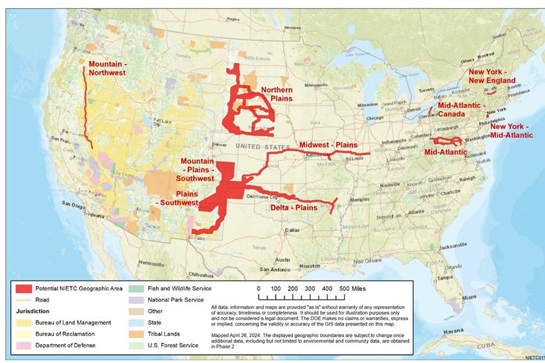
Here is the map of those proposed corridors:
These massive red areas on that map are regions over which DOE wants to seize authority to use federal powers to override state and local government authorities to decide permitting issues related to power transmission projects. In other words, if you own property anywhere inside those red areas, DOE will have the ability to condemn your land to speed up transmission projects, but only for those that would be moving electricity powered by wind and solar industrial projects.
Just how much land are we talking about here? Let’s look at the Midwest-Plains proposed NIETC as one of the simplest examples. DOE says it would be “an approximately 5-mile-wide, 780-milelong east-west geographic area that includes parts of Kansas, Missouri, Illinois, and Indiana.”
So, 5 miles times 780 miles equates to giving DOE the ability to condemn 3,900 square miles of land, or 2,496,000 acres of land across those four states. And that’s one of the smaller red regions on that map.
Here’s the map of the Plains-Southwest region:
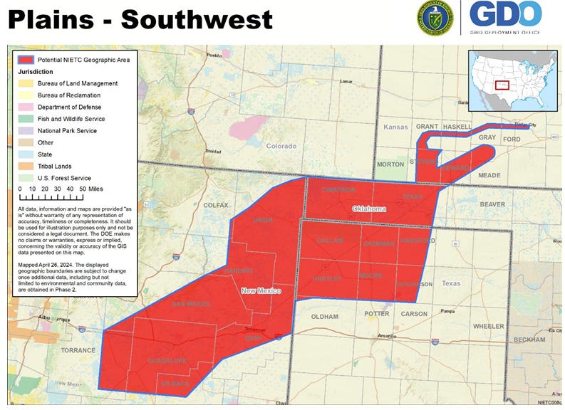
DOE describes that area as follows: “The Plains-Southwest potential NIETC is an approximately 345-mile-long from east to west and 220-mile-long from north to south geographic area of significantly varying width (from less than five miles to near 100 miles).”
Conveniently, DOE studiously refuses to express these regions in terms of square miles or acreage, no doubt specifically because they know the numbers get so huge they would attract public outrage.
Fortunately for all of you, I do not share that concern. It’s impossible from the information provided by DOE to get this precisely right, but a conservative estimate of this one would be to generously estimate it averages roughly 50 miles north-to-south in width (it really looks more like 80-90 miles) and multiply that by its 345-mile east-to-west length. That comes to - wait for it - 17,250 square miles, or 11,040,000 acres of land.
Here’s the map of the Mountain-Plains-Southwest region that is even bigger:
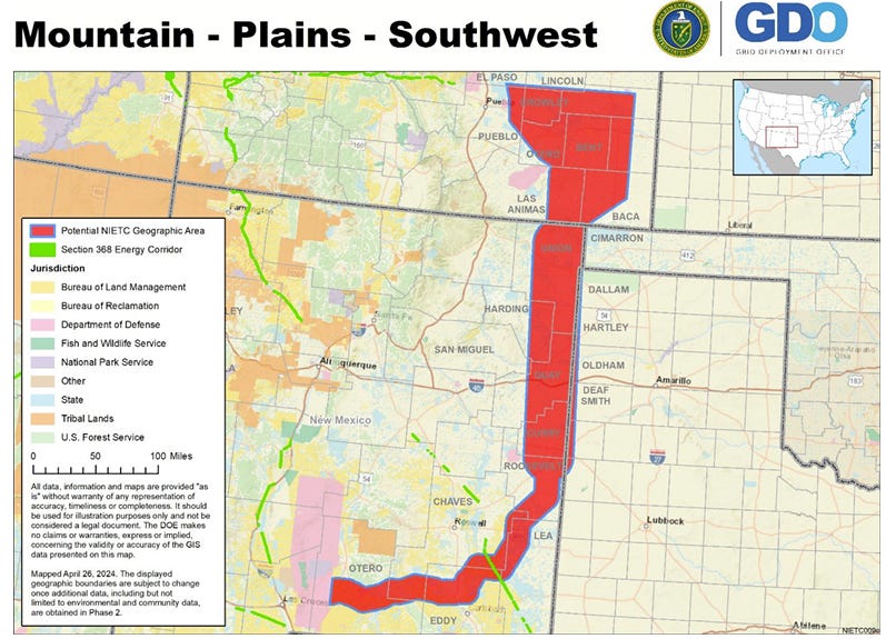
Here’s how DOE describes its geographic footprint: “The Mountain-Plains-Southwest potential NIETC is an approximately 20- to 100 mile-wide, 540-mile-long north-south geographic area from Colorado into New Mexico along the border with Oklahoma and then Texas.”
Conservatively assuming it averages 50 miles in width along that 540 miles in north-south length comes to an astonishing 27,000 square miles for this one, or 17,280,000 acres of land over which DOE would seize condemnation rights from state and local governments.
The Northern Plains region is the biggest one of them all:
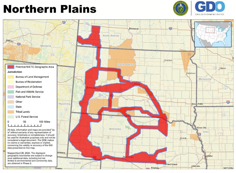
But this one is so complex that I wouldn’t even be able to hazard an estimate of the enormity of its footprint.
In addition to these giant midwestern regions, DOE and Granholm also propose to seize condemnation control over smaller areas in the Northeast and the far West of the country. All told, this constitutes one of the biggest land grabs in our nation’s history.
All in the name of pursuing Biden’s green new deal dreams.
Comments on this plan close next Monday, after which DOE will move to the next step in the process. Those of you in the affected regions should take time to send in comments in opposition to this heinous, unconscionable land grab.
Here are the instructions for commenting:
C. Procedures for Comments and Information Submissions
DOE requests comments and information submissions be made by 5:00 pm ET on June 24, 2024, via email to NIETC@hq.doe.gov. Receiving timely submissions will facilitate DOE’s exercise of its discretion to designate NIETCs in the most efficient and effective manner.
DOE requests submissions be provided in Microsoft Word or PDF format, except for maps and geospatial submissions. There is no page limit on submissions. Interested parties are encouraged to organize information submissions in the manner presented in the NIETC Guidance, including any relevant numbering. DOE requests that information submissions include the name(s), phone number(s), and email address(es) for the principal point(s) of contact, as well as relevant institution and/or organization affiliation and postal address.
[End]
That is all.
I like the post- not the DOE proposal.
Power hungry bureaucrats as usual.
Granholm is one of the worst. A total know nothing in love with herself.
The idiocy is revealed by the dictat that these are for wind and solar only, the least reliable forms of energy .
Someone please save us from these ideologues
Better idea - just say NO. NO to wind, solar, batteries. Just say YES to building gas and coal near where the electricity is needed until the nuke can get built and placed in operation. No need for long haul of low power output generation that needs inversion and transformers to get to line voltage. These DOE people are insane, incompetent, and otherwise just plain old inconsiderate of other people’s rights. Typical of the bozo joe administration.
I can only imagine the uprisings over the federal government seizing land in the middle of the continent. And all for naught, we don’t need to increase the price by forcing renewables on the general public because some politicians donor gave a lot of money (that will be recovered as a siphon off fund from the subsidy) to push the illogical choice.
Its time to make people aware of the choice in the ejection - dictatorial communism or return to freedom in November.